Skip to content The Trail Center

A few miles north of the main portion of Henry Cowell Redwoods State Park lies the Fall Creek Unit, "a second-growth redwood forest with a fern-lined river canyon and remnants of a successful lime-processing industry. Fall Creek is open for day use only, and includes almost twenty miles of connecting trails." (source)

As with most parks in the Santa Cruz mountains range, you should come prepared for any type of weather and layered clothing is recommended.

Park Home Page (external link)

Location: Fall Creek Unit, Henry Cowell Redwoods State Park, Santa Cruz County, California.

Directions: The trailhead is located just outside the town of Felton, on Felton Empire Rd, on the north side of the road, about 0.5 mile west of CA Hwy 9. GPS Coordinates are 37.049212, -122.083412, or roughly 828 Felton Empire Rd, Felton CA, 95018.

Coming from the Peninsula or Valley, use Hwy 17 south towards Santa Cruz, and take exit 3 for Mount Hermon Rd towards Felton/Big Basin. Turn right onto Mount Hermon Rd. Continue 3.5 miles, then turn right on Graham Hill Rd. Cross Hwy 9, then look for the driveway to the trailhead parking about 0.5 mile on your right.

Google Maps link

Agency: California State Parks - Chris Pereira, Supervising Ranger

Supervisor: Dave Croker

Project Lead: Judd Volino

Additional Information: Participants should bring water, sunscreen, sturdy shoes, lunch and normal precautions against poison oak exposure (work gloves, long sleeved shirts and long pants). The Trail Center provides tools, training, gloves, and refreshments after the workday.

Assemble at 8:30 a.m. for our safety talk and crew assignments. Work begins at 9:00 a.m.

This beautiful park has serene walking areas and trails leading to Sugarloaf Mountain. Laurelwood Park & Sugarloaf Mountain (225 acres) is the City of San Mateo's largest contiguous park and open space. This park contains a play area, picnic areas, and restrooms.

Sugarloaf Mountain is San Mateo's green thumb that sticks up just south of Hwy 92. It comprises of open space land that is largely undeveloped, either with homes or trails. There are five steep fire breaks that ambitious hikers use to get to the top for probably the best viewpoint on the mid peninsula.

In 2006 San Mateo developed an in depth master plan for trails on Sugarloaf Mountain with improvements to adjacent Laurelwood Park. In 2011 the city received a grant and highly renovated the playground, picnic area, and added a restroom to Laurelwood Park. But the Sugarloaf Mountain side of the plan was delayed indefinitely for lack of financing and priority. Tom Morse, a Trail Center member, approached the city about getting a trail built on Sugarloaf. By using volunteer labor and just the cost of materials, the City became interested. It took almost 3 years to go through the planning and political process, but finally we were given the "green light" to make this happen. The result was the Amphitheater Trail that climbs from the Tenderfoot Trail near the Laurelwood facilities to access the top of the mountain.

Our project will be to transform a social trail connecting a switchback of the Amphitheater Trail to the Salson Trail.

Park Web Page: Laurelwood Park - City of San Mateo Website

Location: Laurelwood Park/Sugarloaf Mountain, San Mateo, California

Directions: The park is located at 3471 Glendora Dr., San Mateo, CA.

From Interstate 280,take Hwy 92 east:

  • 2nd exit is DeAnza Blvd, exit then make a right turn to be heading downhill on DeAnza.
  • Park across the street from 1400 / 1404 DeAnza.
  • Walk down paved path to meet in front of restrooms.

From Hwy 101, take Hwy 92 west:

  • Take West Hillsdale Blvd exit, then make a left to go downhill.
  • Make a right at stop sign (Gendora Dr).
  • Make a left at first stop sign (Shasta Dr).
  • Follow Shasta Dr till it dead ends at bottom, be aware of red zone parking.
  • Walk down paved path to meet in front of restrooms.

Agency: City of San Mateo

Supervisor: TBD

Project Lead: Marilyn Green

Additional Information: Participants should bring water, sunscreen, sturdy shoes, lunch and normal precautions against poison oak exposure (work gloves, long sleeved shirts and long pants). The Trail Center provides tools, training, gloves, and refreshments after the workday.

Portola Redwoods has a rugged, natural basin forested with Coast Redwoods, Douglas Firs and Live Oaks. There are eighteen miles of trails, a 53 site campground, four group campsites and two beautiful creeks, the Pescadero and Peter''s Creek, that run throughout the park.

The Sequoia Nature Trail, which leads to the Pescadero Creek, introduces visitors to the natural history of the area.

Visitors should come prepared for any type of weather. The park receives between 40 and 60 inches of rain per year and the summer months can be foggy and cool. Layered clothing is recommended at any time of the year.

Location: Portola Redwoods State Park, San Mateo County, California - Upper Coyote Ridge Trail (northern end)

Directions: From Highway 35, turn west onto Alpine Road. From the point at which you start on Alpine Rd. from Skyline Blvd., go 3.4 miles to a Y-intersection. At this intersection, DO NOT follow the sign to the left towards Portola Redwoods SP. Instead, bear right, continuing on Alpine Rd. for another 0.4 mile to the junction with Buffalo Valley Drive. At that point, continue STRAIGHT onto Camp Pomponio Rd. (you'll see a sign for Pescadero Creek County Park) which becomes narrow and rough, for 0.9 mile until reaching the gravel Tarwater Trailhead Parking lot on the left side of the road.

View destination on Google maps

Due to mountain roads, expect a 1 to 1 1/2 hour drive from most Bay Area locations. There is no gasoline available at or near the park. There is no store in or near the park.

Agency: California State Parks - Chris Pereira, Supervising Ranger

Supervisor: Judd Volino

Project Lead: Judd Volino

Additional Information: Participants should bring water, sunscreen, sturdy shoes, lunch and normal precautions against poison oak exposure (work gloves, long sleeved shirts and long pants). The Trail Center provides tools, training, gloves, and refreshments after the workday.

Assemble at 8:30 a.m. for our safety talk and crew assignments. Work begins at 9:00 a.m.

Park Home Page (external link)

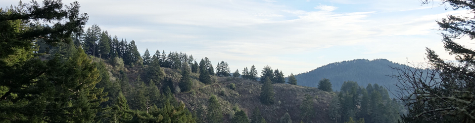
Dedicated in 1872, Alum Rock Regional Park is California's oldest municipal park. Located in the foothills of the Diablo Mountain Range, the park is nestled within the steep confines of the Alum Rock Canyon along Penitencia Creek, which bisects the Park and flows year-round. Once home to the Ohlone Indians, Alum Rock Park features rugged ridges with spectacular views of the Santa Clara Valley, geologic formations including mineral springs and evidence of seismic events, and a wide variety of native flora and fauna (map).

The park’s 740 acres of natural, rugged, beauty provide visitors with many leisure outdoor activities including over 13 miles of unpaved hiking trails varying from fairly level along Penitencia Creek to sharp switchbacks climbing to the ridges to the South Rim and North Rim Trails. The northern trails are open to mountain biking and provide a gateway to the Santa Clara County Open Space Authority’s Sierra Vista Open Space Preserve. The narrow floor of the canyon includes a visitor center, picnic areas, a playground, and sand volleyball pits.

The canyon at Alum Rock has abundant mineral springs, which were touted as beneficial to people's health. In the late 1800s and through the 1930s, the park was famed throughout the country as a health resort. Through those years and as late as the 1970s, the park featured a natatorium (a huge, heated indoor swimming pool), dozens of private heated mineral baths that visitors could rent, a restaurant, and various other buildings. Many of the springs were enclosed in stonework grottos, and stone bridges were built across the creek. An electric railroad brought people from San Jose into the park. In the 1970s, the park removed most of the buildings and began emphasizing the park's natural attractions rather than its manmade ones. However much of the attractive stonework remains, as do old support structures for the railroad.

Special features of the park include 13 miles of hiking trails, the Penitencia Creek which transects the entire park, the Mineral Springs area that contains active mineral springs and grottos, the Gazebo and the Log Cabin which was constructed in 1913.

Website: Alum Rock Park Overview, Alum Rock Park Facility Details

Location: Alum Rock Regional Park, San Jose, California - Stables Trail

Directions: Access is currently available only from Penitencia Creek Road. Use caution if following Internet-based maps to the park! Some lead you to a closed gate. The following address may be used to reach the park entrance with Bing, Apple or Google Maps.

Address: 15295 Penitencia Creek Road San Jose, CA 95132 - (408) 794-7275.

From San Francisco / the Peninsula:

  1. Take US-101 or I-280 south to I-680.
  2. Take I-680 north toward Sacramento (I-280 turns into I-680 in south San Jose).
  3. Take the McKee Road exit, and merge right onto McKee Road heading east towards the hills.
  4. Continue about 0.8 mile along McKee Road.
  5. Turn left on White Road, and continue about 1.2 miles.
  6. Turn right onto Penitencia Creek Road and follow it for about 1.2 miles to the Park Entrance.
  7. After entering the park, follow Penitencia Creek Road to the end of the park, about 2 miles. Speed limit is 20 MPH.
  8. Park and follow the signs to the Sycamore Grove Picnic area / Sycamore Switchbacks Trail trailhead.
  9. Be sure to display your parking pass on front windshield.

From Oakland / I-880 corridor:

  1. Take I-880 south toward San Jose.
  2. Take the Warren Ave/Mission Blvd exit toward I-680. Keep left, follow signs for Mission Blvd/I-680 and continue onto Mission Blvd.
  3. Take the I-680 S ramp toward Milpitas. Merge onto I-680.
  4. Take the Berryessa Rd exit.
  5. Keep left at the fork, follow signs for Berryessa R. East, merge onto Berryessa Rd and continue for about 0.6 mile.
  6. Turn Right onto N Capitol Ave and continue for about 0.3 mile.
  7. Turn left onto Penitencia Creek Rd and follow it for about 2 miles to the Park Entrance.
  8. After entering the park, follow Penitencia Creek Road to the end of the park, about 2 miles. Speed limit is 20 MPH.
  9. Park and follow the signs to the Sycamore Grove Picnic area / Sycamore Switchbacks Trail trailhead.
  10. Be sure to display your parking pass on front windshield.

From the East Bay / I-680 Corridor:

  1. Take the I-680 S toward San Jose.
  2. Take the Berryessa Rd exit.
  3. Keep left at the fork, follow signs for Berryessa R. East, merge onto Berryessa Rd and continue for about 0.6 mile.
  4. Turn Right onto N Capitol Ave and continue for about 0.3 mile.
  5. Turn left onto Penitencia Creek Rd and follow it for about 2 miles to the Park Entrance.
  6. After entering the park, follow Penitencia Creek Road to the end of the park, about 2 miles. Speed limit is 20 MPH.
  7. Park and follow the signs to the Sycamore Grove Picnic area / Sycamore Switchbacks Trail trailhead.
  8. Be sure to display your parking pass on front windshield.

Agency: San Jose Department of Parks, Recreation & Neighborhood Services

Supervisor: Bill Farrell

Project Lead: Larry Stites

Additional Information: Participants should bring water, sunscreen, sturdy shoes, lunch and normal precautions against poison oak exposure (work gloves, long sleeved shirts and long pants).

It can be quite cool in the canyon so dress in layers.

The Trail Center provides tools, training, gloves, and refreshments after the workday.

SIGNUP REQUIRED

The park normally imposes a $6.00 parking fee. Signup for the event to receive a free day-pass and notification of any schedule changes.

Inclement weather conditions may postpone this event.

  • Volunteers 14 and under require prior approval by the project manager and must be accompanied by a parent or guardian.
  • Individual volunteers age 15 to 17 require a waiver signed by a parent or guardian.
  • Groups of volunteers age 15 to 17 require a waiver signed by a parent or guardian for each individual and must be accompanied by one or more supervising adults for every 5 minors.
  • Contact the trail center (volunteer@trialcenter.org) to obtain approval and waivers prior to arrival.

Meet at 8:30 a.m. for safety talk and crew assignments. We will start work at 9:00 a.m. and end at 3:00 p.m.

The Bay Area Ridge Trail ultimately will be a 500+ mile trail encircling the San Francisco Bay along the ridge tops, open to hikers, equestrians, mountain bicyclists, and outdoor enthusiasts of all types. So far over 330 miles of trail has been dedicated for use by Bay Area residents, now and forever.

The REI-Ridge Trail Service day is an annual event in which the Trail Center has participated for many years. This year, we'll be working in the Saratoga Gap Open Space Preserve, partnering with staff from the Midpeninsula Regional Open Space District.

Dedicated as part of the Bay Area Ridge Trail, the nearly two-mile multi-use Saratoga Gap trail parallels Skyline Boulevard (Highway 35), and connects with trails leading to Sanborn-Skyline County Park, Castle Rock and Big Basin State Parks, Upper Stevens Creek County Park, and Long Ridge, Skyline Ridge, and Monte Bello Open Space Preserves, and beyond. The Trail passes under the spreading branches of weathered oaks before dropping into a cool, wooded Douglas fir forest. Trail ends across from the Hickory Oaks trailhead to Long Ridge Open Space Preserve and Highway 35. (Source: MROSD)

Location: Saratoga Gap Open Space Preserve, Santa Clara County - Saratoga Gap Trail

Directions: Parking for volunteers will be at the Caltrans vista point on the southeast corner of the Skyline Boulevard (Highway 35) and Highway 9 intersection.

From the North: Saratoga Gap is approximately 13.7 mi. south of the Highway 84/Skyline Blvd. intersection and 6.5 mi. south of the Page Mill Rd./Skyline Blvd intersections.

From the South/East: use Saratoga Ave or Saratoga-Sunnyvale Rd. to get onto Highway 9/Big Basin Way and proceed approximate 7.3 mi. to reach Skyline Blvd.

View destination on Google Maps

Agency: Midpeninsula Regional Open Space District

Supervisor: Hank Magnuski

Project Lead: Hank Magnuski

Additional Information: Participants should bring water, sunscreen, sturdy shoes and normal precautions against poison oak exposure (work gloves, long sleeved shirts and long pants). The Trail Center provides tools, training, gloves, and refreshments after the workday. Typically Chipotle provides a burrito for each participant at lunch time during this event.

Wunderlich Park, a hillside area of redwood forest, open meadows, and beautiful oaks and madrones, this area was once the ranch of the Folger family and was donated to the County by Martin Wunderlich. The park is largely open space, with a system of beautiful trails. Both, riding and hiking are available.

Location: Wunderlich County Park, Woodside, California - Bear Gulch Trail

Directions: 4040 Woodside Road, Woodside 94062 - (650)851-1210

- From the North
Turn off at the Woodside Road (Highway 84) exit. Turn westbound (towards Woodside). Proceed approximately 3 miles through the Town of Woodside. The main park entrance will be on the west (right) side of the roadway. The entrance sign is wooden and next to a yellow emergency phone box. Pay attention to your speed in Woodside or you'll be involuntarily contributing to the General Fund.

- From the South
Take the 280 Sand Hill exit west. Go on past the Whisky Hill intersection, up and over a small hill, and turn right onto Portola Road just after passing the gate to Jasper Ridge preserve. Bear left at the Y, staying on Portola. Portola will T into 84 (Woodside Road), turn right on 84. After half a mile or so watch for the Wunderlich entrance on the left. (Clearly signed; don't be fooled by an entrance to a private stable area.)

Agency: San Mateo County Parks - Carla Schoof, San Mateo Volunteer Coordinator

Supervisor: Hank Magnuski

Project Lead: Hank Magnuski

Additional Information: Participants should bring water, sunscreen, sturdy shoes, lunch and normal precautions against poison oak exposure (work gloves, long sleeved shirts and long pants). The Trail Center provides tools, training, gloves, and refreshments after the workday.

Memorial Park with its 499 acres provides an opportunity to view outstanding old-growth redwoods and has picnic facilities, a visitor center, a camp store, a creek swimming area, and campfire programs. The park is known for its family camping areas and the Tan Oak and Mt. Ellen Nature Trails.

Timber surrounding this area was logged in the late 1800's and early 1900's, both for redwood lumber and the bark of the tan oak tree. In fact, four small sawmill sites are either on or adjacent to the present park boundaries. Fortunately, many of the areas in the park were saved from the logger's saws and were eventually acquired by the County in 1924. The park was memorialized for for the men of San Mateo County who died in the First World War.

The Depression brought many to the area when Memorial Park was established as a project camp for the Work Projects Administration created by President Roosevelt. Many of the existing restrooms, roadways and picnic sites are the result of their efforts.

Thousands of campers use the Creek Trail during the spring and summer seasons. They love to follow the river and enjoy it. The park can fit 2200 campers in their campgrounds during the summer, and most of those folks eventually find their way down to the creek. So, for the past 10 years, they've had to stumble through the rough terrain of the use trail that has developed since the trail disappeared. The trail was originally built in the 60's, so it lasted 30 years. The nearby Homestead Trail is used by local residents to walk to Loma Mar and elsewhere.

Location: Memorial Park, San Mateo County, California

Directions: When coming to Memorial Park from the bayside of the peninsula, use Highway 84 west from either Highway 280, 101 or 35 (Skyline Boulevard). Travel westbound down Highway 84 from Skyline Boulevard to Pescadero Road through the Town of La Honda. Turn left (south) on Pescadero Road. Follow Pescadero Road 5.6 miles to the park entrance (note be careful not to go straight onto Alpine Road; Pescadero road curves to the right uphill).

As you travel through the town of Woodside, please note that the speed limit is 25 m.p.h. Otherwise, you might be involuntarily contributing to the Woodside General Fund.

When coming to Memorial Park from the coastside, use Highway 1 to Pescadero Road. Follow Pescadero Road 9.3 miles to the park entrance.

The parking/meeting area is going to be the parking lot immediately in front of the Memorial Park entrance kiosk on the south side of the road.

Additional Information: Participants should bring water, sunscreen, sturdy shoes, lunch and normal precautions against poison oak exposure (work gloves, long sleeved shirts and long pants). The Trail Center provides tools, training, gloves, and refreshments after the workday.

Assemble at 8:30 for safety talks and crew assignments. We will start work on the trail at 9:00.

All park entry fees will be waived for volunteers.

Agency: San Mateo County Parks - David Vasquez, Supervising Ranger

Every November members of the Trail Center gather to scrub, sharpen, wash and paint the tools and equipment we use during the year for our monthly builds.

This fun event combines work, cameraderie, good food and entertainment to accomplish the necessary tasks required to keep our mattocks, McLeods, picks and shovels in top condition.

All Trail Center members are invited to come and participate. The annual meeting and officer elections are held after the tools are put away. The day ends with a special presentation by one of the Trail Center members or a guest speaker.

Location: Palo Alto, California - Annual Tool Party

Directions: From 101 exit west onto Oregon Expressway in Palo Alto. At the third stoplight take a right turn onto Louis and continue to the stop sign. Make a left turn onto Northern California, and take the first right onto Barbara Drive.

From 280 and Page Mill Expressway, head east to Oregon Expressway. After crossing El Camino, head about 4 or 5 blocks to Middlefield Avenue and take a left turn. Head north on Middlefield about two blocks and take a right turn onto Northern California, which is at the corner of Jordan School. Head east on Northern California past Newell and then make a left on Barbara Drive, which ends by Stratford School.

The location is 2019 Barbara Drive, Palo Alto, California. Contact Hank Magnuski (650) 714-2409 for more information.

Agency: Trail Center

Supervisor: Dave Croker

Project Lead: Hank Magnuski

Additional Information: Bring work gloves, rags, electric drills with brush attachments (if you have such equipment), high spirits, good stories and some friends.

Portola Redwoods has a rugged, natural basin forested with Coast Redwoods, Douglas Firs and Live Oaks. There are eighteen miles of trails, a 53 site campground, four group campsites and two beautiful creeks, the Pescadero and Peter''s Creek, that run throughout the park.

The Sequoia Nature Trail, which leads to the Pescadero Creek, introduces visitors to the natural history of the area.

Visitors should come prepared for any type of weather. The park receives between 40 and 60 inches of rain per year and the summer months can be foggy and cool. Layered clothing is recommended at any time of the year.

Location: Portola Redwoods State Park, San Mateo County, California - Slate Creek and Summit Trails

Directions: From Highway 35, turn west onto Alpine Road, go 3 miles, and turn (bear left) onto Portola State Park Road. The road dead ends in the park. Use low gear as both these roads are steep and winding.

Due to mountain roads, expect a 1 1/2 to 2 hour drive from most Bay Area locations. There is no gasoline available at or near the park. There is no store in or near the park.

Agency: California State Parks - Chris Pereira, Supervising Ranger

Supervisor: TBD

Project Lead: Judd Volino

Additional Information: Participants should bring water, sunscreen, sturdy shoes, lunch and normal precautions against poison oak exposure (work gloves, long sleeved shirts and long pants). The Trail Center provides tools, training, gloves, and refreshments after the workday.

Assemble at 8:30 a.m. for our safety talk and crew assignments. Work begins at 9:00 a.m.

Park Home Page (external link)